
ALTHOUGH yesterday (Friday the 21st) was a lovely sunny day here in the ass end of Metro Manila – by my count, the first day in at least 12 with no rain at all – the weather this morning, while still pleasant, seems a bit unsettled. The national weather bureau here, although comprising bright, energetic people, is badly underfunded and has woefully insufficient resources to forecast inclement weather with anything remotely approaching the degree of accuracy we take for granted in the western world, and so I (and I’m sure I’m not the only one) have learned to apply some amateur weather-watching skills.
The best resource for this on a regular basis is Windy.com; when tropical cyclones are developing, the go-to supplements for further information are the Joint Typhoon Warning Center (JWTC) and Tropical Storm Risk (TSR). The JWTC is a joint agency of the US National Oceanographic and Atmospheric Administration (NOAA) and the US Naval Research Lab (NRL), and is responsible for oceanic weather forecasting for the US Navy and Air Force. TSR is a private company that makes most of its revenue by providing weather forecasting for the shipping industry, and more to the point, shipping insurance underwriters. Thus, both agencies have a critical motivation to get their information right, which is highly reliable for ordinary slobs like the rest of us.
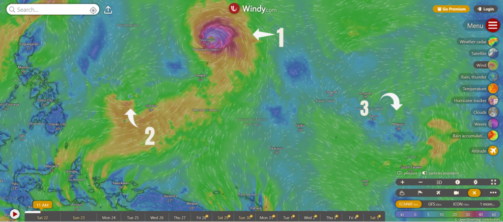
Anyway, I along with everyone else in the northern two-thirds of the Philippines is wondering how long our respite from relentless rains will last. The answer, apparently, is not long; as I said, yesterday was a lovely day, today there are already signs that the weather is starting to turn, although it hasn’t yet, at least as of lunchtime here in Metro Manila. The overview from Windy.com, from about 8:00 o’clock this morning local time, is not promising:
Number 1 is Typhoon Saudel, currently at about Category 2 strength, and on its way to Okinawa. It will not be a direct problem for the Philippines, but it will drag the Southwest Monsoon (called the habagat here) across the country, bringing more heavy rains.
Number 2 is a low pressure area (designated 97W by the JTWC) that will turn into a tropical storm within about 48 hours, or around sometime midday on Monday, Aug. 24. It may not hit the Philippines, or it may plow straight across Southern Luzon and the Northern Visayas. Either way, it will also cause a great deal of rainfall.
Number 3, which no one seems to have taken notice of yet, is potentially the worst. It is an area of lower pressure and tropical circulation forming in the “typhoon nursery” in the Marshall Islands, and it wasn’t there 6 hours before I took this screenshot. The worst typhoons to hit the Philippines historically have all been born in that exact area. It could fizzle out, of course, but the current JTWC advice is that conditions for tropical cyclone formation are favorable, although it would likely not develop for another 2 or 3 days. Again, even if it swings away from making landfall, it is likely to aggravate the monsoon, and cause more rain here.
Man, fuck a buncha rain. The bitter irony of this is that, within 4 to 5 months’ time, we are almost certainly going to be experiencing severe drought conditions, due to the strong El Niño in the eastern Pacific. Drown now, bake later.