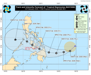
IT would be understandable, given everything that has been happening, if people haven’t yet noticed it, but the weather in this part of the world is doing some strange and worrisome things. To illustrate, here are the two latest forecast graphics from the Joint Typhoon Warning Center:
The top graphic is of a storm called Cyclone Maila, and it was posted at 0300 GMT today (April 10), which is 11:00 am local time here in Manila. The lower graphic is of Tropical Storm Sinlaku, and the JTWC posted it at 0900 GMT, or 5:00 pm where I am. Both of these storms are rather unusual, for different reasons.
Maila, as you can see from the chart, has been wobbling around the center of the Solomon Sea for several days, and is only now beginning to move in a more-or-less normal path for a southern hemisphere cyclone. It is not particularly strange that the storm has formed at this time of the year, because it is in the southern hemisphere, but it is somewhat unusual that it formed where it did. And extremely unusual for behaving in such a spastic fashion.
Tropical Storm Sinlaku, on the other hand, is a somewhat unusual early-season storm; the northwestern Pacific typhoon season typically runs from June to December, although storms can form at any time of the year. April storms only happen every two to three years, and tend to catch people off guard. Case in point, a friend of mine who visits Guam regularly just left a couple of days ago, and almost immediately (and prudently) turned tail and left on one of the few remaining flights out. What is a bit alarming about Sinlaku is that it is exploding in strength, going from a bit of grunky weather to a strong tropical storm in a matter of about 12 hours, and expected to be a Category 4 or 5 typhoon by the time it reaches Guam in a bit less than two days at its current speed.
The really fascinating thing, however, is how the two storms have developed seemingly in tandem. Sinlaku and Maila are on an almost straight north-south line, about 20 degrees apart (roughly 1,300 nautical miles), but on opposite sides of the Equator. That is likely just a coincidence, but to some (present company included) it is an ill omen of a bad storm season to come.
Last year, despite about 23 storms entering the Philippine Area of Responsibility – an imaginary box encompassing the country, stretching as far north as Taiwan and as far east as Palau – we had a rather tame season by local standards. There were a few storms that made landfall here, but only one really bad one, Typhoon Tino (international name Kalmaegi) during the first week of November. That’s relative, of course; as one of the most disaster-prone countries in the world, some number of casualties and amount of weather-related destruction in any given year is to be expected. But in a “normal” year, it is not at all unusual to have four or five typhoons of a severity that would have people in hurricane-prone places in the States crying for their mommas.
Over a long arc of observation, for example, the nearly 22 years I have been in this country, it is not hard to conclude that human-induced climate change is making things worse. The hot months are progressively hotter, year after year, the wet months are progressively wetter, and the bad storms are progressively more severe.
Fortunately, it is unlikely that Sinlaku will make it all the way to the Philippines; it will almost certainly curve north across the Philippine Sea, and give people in Japan’s southern islands a bad time in the next week or so. But taken together with a cyclone that seems to be twinning it on the other side of the Equator, it seems to be a bad sign that we are going to be in for a rough time this year. And sometime in the near future – maybe this year, maybe next, maybe the one after that – we’re going to have a year that will be too rough to endure, or recover from.